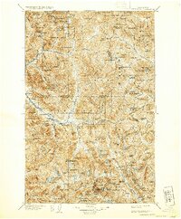
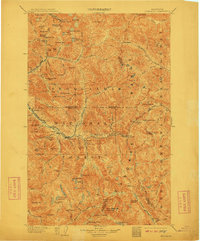
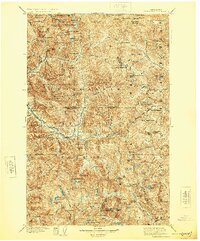
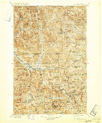
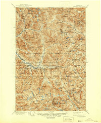
1905 Map of Skykomish
USGS Topo · Published 1932About this map
The Great Northern Railway dictates the development of this mountainous corridor, following the South Fork Skykomish River and the Tye River toward the engineering feat of the Cascade Tunnel. This 1905 survey, reprinted in 1932, illustrates the vital connection between transportation and the region's mining and timber beginnings. Near the northern boundary, the mining camps of Monte Cristo and Mineral City are linked to the rails by rugged terrain and feeder streams like Silver Lake and Quartz Creek. While Skykomish serves as a central hub, smaller rail-side locations like Grotto, Berlin, and Tonga highlight the sparse but strategic settlement pattern established before the turn of the century. The map also documents early county boundaries where Snohomish County and King County meet, showing how the high peaks of the Cascade Range defined the physical and political limits of the era.
Find a feature on this map
207 named features on this map. Tap any name to fly to it.
Don’t see what you’re looking for? This feature index may not catch every label — zoom into the map to look around manually.
Map Details
Editions of this 1905 Skykomish Map
7 editions found

Other maps of this area

1897 · Mount Stuart
USGS Topo · 1:125,000

1899 · Glacier Peak
USGS Topo · 1:125,000

1899 · Stillaguamish
USGS Topo · 1:125,000

1901 · Glacier Peak
USGS Topo · 1:125,000

1901 · Stilaguamish
USGS Topo · 1:125,000

1901 · Chiwaukum
USGS Topo · 1:125,000

1901 · Snoqualmie Pass
USGS Topo · 1:125,000

1902 · Skykomish
USGS Topo · 1:125,000

1902 · Mount Stuart
USGS Topo · 1:125,000

1902 · Stehekin
USGS Topo · 1:125,000