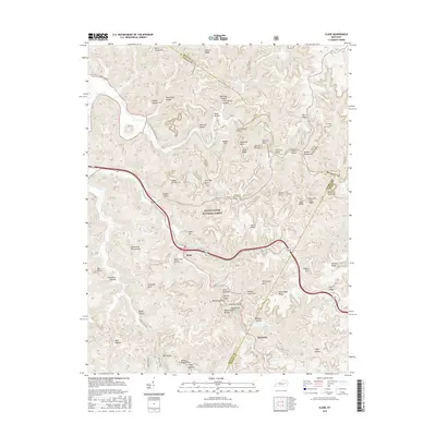
2016 Map of Slade
USGS Topo · Published 2016About this map
The Red River winds through a deeply dissected landscape within the Daniel Boone National Forest, where the unique geology of the Cumberland Plateau is evidenced by numerous natural sandstone spans and prominent rock formations. This 2016 survey details the intricate network of ridges and hollows surrounding the settlement of Slade, a vital access point for the region. Notable landmarks such as Courthouse Rock, Haystack Rock, and the Nada Tunnel highlight the early 20th-century engineering required to navigate this terrain. The map records a high concentration of natural arches, including the Nada Arches, Grays Arch, and the Slade Twin Arches. Local geography is further defined by family-named features like Tom Chrisp Hollow and Amburgy Hollow, while topographic extremes are captured at Pinch-Em Tight Gap and along the sharp elevations of Auxier Ridge and Tunnel Ridge.
Find a feature on this map
64 named features on this map. Tap any name to fly to it.
Don’t see what you’re looking for? This feature index may not catch every label — zoom into the map to look around manually.
Map Details
Editions of this 2016 Slade Map
This is the sole edition of this map. No revisions or reprints were ever made.
Other maps of this area

1892 · Beattyville
USGS Topo · 1:125,000

1951 · Pomeroyton
USGS Topo · 1:24,000

1952 · Scranton
USGS Topo · 1:24,000

1952 · Frenchburg
USGS Topo · 1:24,000

1952 · Stanton
USGS Topo · 1:24,000

1952 · Means
USGS Topo · 1:24,000

1952 · Slade
USGS Topo · 1:24,000

1952 · Cobhill
USGS Topo · 1:24,000
1952 · Campton
USGS Topo · 1:24,000

1953 · Zachariah
USGS Topo · 1:24,000