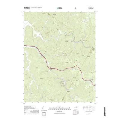
2019 Map of Slade
USGS Topo · Published 2019About this map
The community of Slade serves as the focal point of this map, situated where the Bert T Combs Mountain Parkway meets the complex geography of the Daniel Boone National Forest. The landscape is defined by the Red Wild and Scenic River and its intricate network of tributaries like Whittleton Br and Martin Fork. This survey documents a region renowned for its unique geological formations, highlighting landmarks such as Courthouse Rock, Haystack Rock, and the engineering of the Nada Tunnel. Downriver to the southeast, the settlement of Glencairn is positioned near Mill Cr Lake, illustrating the cluster of small communities that historically developed along these narrow valley floors. The mapping of numerous arches, including Grays Arch and Whittleton Arch, along with named heights like Hatton Ridge and Tarr Ridge, reveals the deeply dissected nature of the Cumberland Plateau in eastern Kentucky.
Find a feature on this map
112 named features on this map. Tap any name to fly to it.
Don’t see what you’re looking for? This feature index may not catch every label — zoom into the map to look around manually.
Map Details
Editions of this 2019 Slade Map
This is the sole edition of this map. No revisions or reprints were ever made.
Other maps of this area

1892 · Beattyville
USGS Topo · 1:125,000

1951 · Pomeroyton
USGS Topo · 1:24,000

1952 · Scranton
USGS Topo · 1:24,000

1952 · Frenchburg
USGS Topo · 1:24,000

1952 · Stanton
USGS Topo · 1:24,000

1952 · Means
USGS Topo · 1:24,000

1952 · Slade
USGS Topo · 1:24,000

1952 · Cobhill
USGS Topo · 1:24,000
1952 · Campton
USGS Topo · 1:24,000

1953 · Zachariah
USGS Topo · 1:24,000