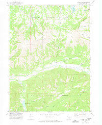
1972 Map of Slader Basin
USGS Topo · Published 1974About this map
The Wasatch National Forest dominates this high-altitude landscape in northern Utah, where the headwaters of the Weber River carve through the mountain basins. The 1972 survey captures the area’s role as a recreational and agricultural frontier, anchored by the Smith and Morehouse Reservoir and its adjacent Campground. The terrain is defined by prominent peaks and ridges, including the 10,700-foot Humpy Peak and the sweeping Windy Ridge. A network of water sources like Blue Lake and Boyer Lake feed into numerous drainages such as Larrabee Creek and Stillman Creek. Practical land use is evident at the Thousand Peaks Ranch, while the interior remains accessible primarily via the Slader Trail and various jeep trails that navigate the high-country topography of Slader Basin and Moffit Basin.
Find a feature on this map
30 named features on this map. Tap any name to fly to it.
Don’t see what you’re looking for? This feature index may not catch every label — zoom into the map to look around manually.
Map Details
Editions of this 1972 Slader Basin Map
2 editions found
Other maps of this area

1885 · Salt Lake
USGS Topo · 1:250,000

1885 · Uinta
USGS Topo · 1:250,000

1900 · Coalville
USGS Topo · 1:125,000

1901 · Hayden Peak
USGS Topo · 1:125,000

1903 · Hayden Peak
USGS Topo · 1:125,000

1903 · Coalville
USGS Topo · 1:125,000

1954 · Salt Lake City
USGS Topo · 1:250,000

1958 · Salt Lake City
USGS Topo · 1:250,000

1960 · Salt Lake City
USGS Topo · 1:250,000
1967 · Upton
USGS Topo · 1:24,000