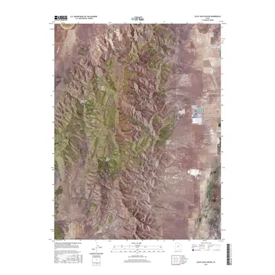
2017 Map of Slate Jack Canyon
USGS Topo · Published 2017About this map
Goshen Valley and the northern reaches of Long Ridge define the landscape of this 2017 survey along the border of Utah and Juab counties. This transition from the valley floor into the eastern West Hills is marked by a complex network of drainages and named canyons, including the prominent Slate Jack Canyon and the uniquely named Goosenest Canyon. Small-scale water sources are vital features in this arid environment, with mapped locations such as Slate Jack Spring, Cottonwood Spring, and Lunt-Lattimer Spring indicating the importance of reliable water for land management and early settlement. Along the eastern edge of the ridge, the Mona Reservoir serves as a major landmark near the Swasey Family Cem, highlighting the area's genealogical roots. The terrain is further distinguished by the geological formations of The Devils Steps and the secluded basin of Dog Valley.
Find a feature on this map
32 named features on this map. Tap any name to fly to it.
Don’t see what you’re looking for? This feature index may not catch every label — zoom into the map to look around manually.
Map Details
Editions of this 2017 Slate Jack Canyon Map
This is the sole edition of this map. No revisions or reprints were ever made.
Other maps of this area

1885 · Manti
USGS Topo · 1:250,000

1885 · Sevier Desert
USGS Topo · 1:250,000

1895 · Manti
USGS Topo · 1:250,000

1949 · Eureka
USGS Topo · 1:24,000

1951 · Santaquin
USGS Topo · 1:62,500

1951 · Nephi
USGS Topo · 1:62,500

1953 · Delta
USGS Topo · 1:250,000

1954 · Tintic Mountain
USGS Topo · 1:24,000
1954 · Eureka
USGS Topo · 1:24,000

1956 · Price
USGS Topo · 1:250,000