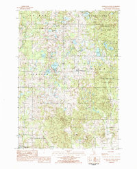
1983 Map of Slaybaugh Corner
USGS Topo · Published 1984About this map
Slaybaugh Corner and the surrounding townships of Cedar and Lincoln are defined by a high concentration of glacial lakes and wetlands within the Pere Marquette State Forest. This early 1980s survey captures the rural character of Osceola County, where small community centers like Townhall and the Eagle Boys Village dot the landscape. Local history and genealogy are anchored by the Bethel Ch and adjacent Bethel Cem, situated near the headwaters of Indian Creek. The map documents a complex drainage system, showing how Hersey Creek and its branches, including East Branch Hersey Creek, wind through the moraine topography. To the south, the periphery of Reed City and the Spring Valley Golf Course indicate the transition toward more developed corridors, while the northern reaches remain dominated by water bodies like Todd Lake, Austin L, and Eggleston Lake.
Find a feature on this map
38 named features on this map. Tap any name to fly to it.
Don’t see what you’re looking for? This feature index may not catch every label — zoom into the map to look around manually.
Map Details
Editions of this 1983 Slaybaugh Corner Map
This is the sole edition of this map. No revisions or reprints were ever made.
Other maps of this area

1931 · Chase NE
USGS Topo · 1:31,680

1933 · Luther SE
USGS Topo · 1:31,680

1954 · Traverse City
USGS Topo · 1:250,000

1954 · Midland
USGS Topo · 1:250,000

1957 · Cadillac South
USGS Topo · 1:62,500

1957 · Luther
USGS Topo · 1:62,500

1958 · Traverse City
USGS Topo · 1:250,000

1958 · Midland
USGS Topo · 1:250,000

1959 · Midland
USGS Topo · 1:250,000

1959 · Evart
USGS Topo · 1:62,500