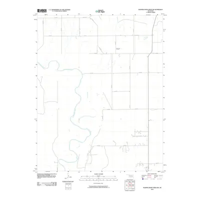
2010 Map of Sleeping Bear Creek SW
USGS Topo · Published 2010About this map
The North Canadian River meanders across this rural section of Woodward County, creating a winding riparian corridor through the high plains. This 2010 topographic representation shows a landscape defined by a precise section-line road grid, including N2010 Rd and E0280 Rd, which service the agricultural parcels of the region. The map captures the quiet development at Quail Ridge Acres, a small residential cluster that contrasts with the surrounding open ranching and farming land. For those researching family history in the area, the Rock Church Cemetery is a significant landmark, situated near the intersection of N2020 Rd and E0290 Rd. The terrain remains largely open, with subtle elevation changes indicated by the ten-foot contour intervals typical of this part of Oklahoma.
Find a feature on this map
18 named features on this map. Tap any name to fly to it.
Don’t see what you’re looking for? This feature index may not catch every label — zoom into the map to look around manually.
Map Details
Editions of this 2010 Sleeping Bear Creek SW Map
This is the sole edition of this map. No revisions or reprints were ever made.
Other maps of this area

1955 · Woodward
USGS Topo · 1:250,000

1958 · Woodward
USGS Topo · 1:250,000

1969 · Fargo
USGS Topo · 1:24,000

1969 · Woodward
USGS Topo · 1:24,000

1969 · Woodward NE
USGS Topo · 1:24,000

1970 · Sleeping Bear Creek SW
USGS Topo · 1:24,000

1970 · Sleeping Bear Creek NW
USGS Topo · 1:24,000

1970 · Sleeping Bear Creek SE
USGS Topo · 1:24,000

1971 · Fort Supply
USGS Topo · 1:24,000

1971 · Fort Supply NE
USGS Topo · 1:24,000