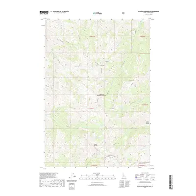
2020 Map of Sleeping Deer Mountain
USGS Topo · Published 2020About this map
Sleeping Deer Mtn dominates this high-elevation wilderness within the Challis National Forest, providing a central point for a complex network of alpine ridges and glacial basins. The presence of Sleeping Deer Lo indicates a site for fire surveillance, overlooking the diverse drainages of Woodtick Creek and Grouse Creek. The landscape is defined by its verticality, with prominent landmarks such as Martin Mtn, Woodtick Ridge, and Macarte Ridge forming natural dividers between numerous mountain lakes. These water bodies, including Woodtick Lake, Cache Cr Lakes, and Rock Lakes, suggest a geography shaped by glacial activity. For those interested in the remote backcountry of Lemhi County, the map traces limited access routes such as the Sleeping Deer Road and the Woodtick Cutoff, which traverse the high passes and meadows like Horse Heaven Meadows.
Find a feature on this map
45 named features on this map. Tap any name to fly to it.
Don’t see what you’re looking for? This feature index may not catch every label — zoom into the map to look around manually.
Map Details
Editions of this 2020 Sleeping Deer Mountain Map
This is the sole edition of this map. No revisions or reprints were ever made.
Other maps of this area

1930 · Casto
USGS Topo · 1:125,000

1957 · Challis
USGS Topo · 1:250,000

1960 · Challis
USGS Topo · 1:250,000

1962 · Bear Creek Point
USGS Topo · 1:24,000

1962 · Ramey Hill
USGS Topo · 1:24,000

1963 · Challis
USGS Topo · 1:250,000

1963 · Meyers Cove
USGS Topo · 1:24,000

1963 · Rock Creek
USGS Topo · 1:24,000
1963 · Aparejo Point
USGS Topo · 1:24,000
1963 · Yellowjacket
USGS Topo · 1:24,000