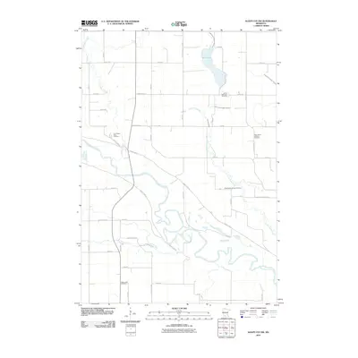
2010 Map of Sleepy Eye NW
USGS Topo · Published 2010About this map
The Minnesota River carves a winding path through this landscape in Nicollet County, creating a valley defined by intricate oxbows and riparian terrain. The surrounding uplands are marked by an organized grid of county roads and family-named routes such as Golden Gate Rd and Fort Rd. For those researching local history, the area is notable for its numerous small burial grounds, including the Fort Ridgely State Cemetery near the creek that shares its name, and the Loffelmacher Private Cemetery situated along the bends of Little Rock Creek. Water management is a prominent feature of the rural landscape, visible through engineered waterways like Judicial Ditch Number Thirteen and Judicial Ditch Number Thirtyone, which direct drainage toward the larger river system. To the north, Mud Lake remains a significant local landmark in this prairie-river environment.
Find a feature on this map
45 named features on this map. Tap any name to fly to it.
Don’t see what you’re looking for? This feature index may not catch every label — zoom into the map to look around manually.
Map Details
Editions of this 2010 Sleepy Eye NW Map
This is the sole edition of this map. No revisions or reprints were ever made.
Other maps of this area

1952 · Morton
USGS Topo · 1:62,500

1953 · Morgan
USGS Topo · 1:62,500

1953 · New Ulm
USGS Topo · 1:250,000

1957 · New Ulm
USGS Topo · 1:250,000

1958 · New Ulm
USGS Topo · 1:250,000

1964 · Fairfax
USGS Topo · 1:24,000

1964 · Sleepy Eye NW
USGS Topo · 1:24,000

1964 · Sleepy Eye
USGS Topo · 1:24,000

1964 · Essig
USGS Topo · 1:24,000

1964 · St George
USGS Topo · 1:24,000