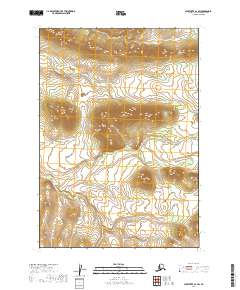
2019 Map of Sleetmute A-1 SW
USGS Topo · Published 2019About this map
Door Mountains dominate the upper elevations of this interior Alaskan landscape within the Bethel Census Area. The topography is defined by the drainage patterns of Door Cr, which winds through the central and northern sections of the sheet. Surveyed by the U.S. Geological Survey, this map illustrates the remote character of the region, where natural landforms take precedence over human development. The elevation contours reveal the complex ridges and valleys that shape the southern reach of the Door Mountains, offering a clear view of the wilderness as it was documented in the early 21st century.
Find a feature on this map
6 named features on this map. Tap any name to fly to it.
Don’t see what you’re looking for? This feature index may not catch every label — zoom into the map to look around manually.
Map Details
Editions of this 2019 Sleetmute A-1 SW Map
This is the sole edition of this map. No revisions or reprints were ever made.
Other maps of this area

1950 · Sleetmute
USGS Topo · 1:250,000

1950 · Taylor Mountains
USGS Topo · 1:250,000

1951 · Taylor Mountains
USGS Topo · 1:250,000

1954 · Sleetmute
USGS Topo · 1:250,000

1954 · Taylor Mountains
USGS Topo · 1:250,000

1954 · Taylor Mountains D-1
USGS Topo · 1:63,360
1954 · Sleetmute A-1
USGS Topo · 1:63,360

1954 · Taylor Mountains D-2
USGS Topo · 1:63,360
1954 · Sleetmute A-2
USGS Topo · 1:63,360
2019 · Taylor Mountains D-2 NE
USGS Topo · 1:25,000