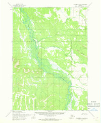
1954 Map of Sleetmute A-2
USGS Topo · Published 1968About this map
The Hoholitna River meanders through this interior Alaska landscape, defining a broad valley of wetlands and complex oxbow formations as it appeared in the mid-1950s. The topographic data, compiled by the Army Map Service, illustrates a wilderness largely untouched by permanent settlements or roads at the time of the survey. To the east, the terrain rises into the Door Mountains, where Door Creek drains toward the main river channel. This map represents an era of surveying where land lines were predetermined by the Bureau of Land Management but remained largely unsurveyed on the ground. The lack of man-made infrastructure underscores the reliance on river systems for navigation through the Seward Meridian during this period of aerial photogrammetric mapping.
Find a feature on this map
3 named features on this map. Tap any name to fly to it.
Don’t see what you’re looking for? This feature index may not catch every label — zoom into the map to look around manually.
Map Details
Editions of this 1954 Sleetmute A-2 Map
This is the sole edition of this map. No revisions or reprints were ever made.
Other maps of this area

1950 · Sleetmute
USGS Topo · 1:250,000

1950 · Taylor Mountains
USGS Topo · 1:250,000

1951 · Taylor Mountains
USGS Topo · 1:250,000

1954 · Sleetmute
USGS Topo · 1:250,000

1954 · Taylor Mountains
USGS Topo · 1:250,000

1954 · Sleetmute B-2
USGS Topo · 1:63,360
1954 · Taylor Mountains D-3
USGS Topo · 1:63,360

1954 · Sleetmute B-3
USGS Topo · 1:63,360

1954 · Taylor Mountains D-1
USGS Topo · 1:63,360
1954 · Sleetmute A-3
USGS Topo · 1:63,360