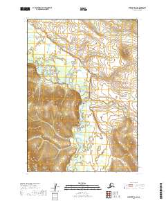
2019 Map of Sleetmute A-2 SE
USGS Topo · Published 2019About this map
The Hoholitna River winds through the heart of this landscape in the Bethel Census Area, creating a complex drainage network that defines the local geography. This 2019 survey documents the river as it flows through the western and central portions of the quadrangle, flanked by rising elevation to the east. Highlighting the hydrography of this interior region, the map also identifies Door Cr in the northeast corner. The terrain is structured by the Public Land Survey System, with the intersections of t12n r41w, t12n r40w, t11n r41w, and t11n r40w providing a framework for understanding land divisions in this part of Alaska. It is a focused study of natural watercourses and the legal survey lines that partition the wilderness.
Find a feature on this map
6 named features on this map. Tap any name to fly to it.
Don’t see what you’re looking for? This feature index may not catch every label — zoom into the map to look around manually.
Map Details
Editions of this 2019 Sleetmute A-2 SE Map
This is the sole edition of this map. No revisions or reprints were ever made.
Other maps of this area

1950 · Sleetmute
USGS Topo · 1:250,000

1950 · Taylor Mountains
USGS Topo · 1:250,000

1951 · Taylor Mountains
USGS Topo · 1:250,000

1954 · Sleetmute
USGS Topo · 1:250,000

1954 · Taylor Mountains
USGS Topo · 1:250,000

1954 · Taylor Mountains D-1
USGS Topo · 1:63,360
1954 · Sleetmute A-1
USGS Topo · 1:63,360

1954 · Taylor Mountains D-2
USGS Topo · 1:63,360
1954 · Sleetmute A-2
USGS Topo · 1:63,360
2019 · Taylor Mountains D-2 NE
USGS Topo · 1:25,000