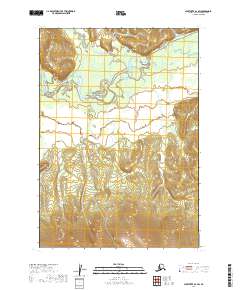
2019 Map of Sleetmute A-4 SW
USGS Topo · Published 2019About this map
The Holitna River meanders across the northwestern reaches of this remote Alaskan interior landscape, joined by the Chuithluk River as it winds through the Bethel Census Area. The topography transitions from broad, low-lying river valleys and wetlands in the north to increasingly prominent ridges in the south. The absence of roads or established settlements emphasizes the wilderness character of the region, where the drainage patterns of these major waterways dictate the shape of the land. This 2019 survey documents the complex hydrological networks of the Sleetmute region, tracing the intricate loops and oxbows of the river systems within the township boundaries of T12N R46W and T11N R46W.
Find a feature on this map
6 named features on this map. Tap any name to fly to it.
Don’t see what you’re looking for? This feature index may not catch every label — zoom into the map to look around manually.
Map Details
Editions of this 2019 Sleetmute A-4 SW Map
This is the sole edition of this map. No revisions or reprints were ever made.
Other maps of this area

1950 · Sleetmute
USGS Topo · 1:250,000

1950 · Taylor Mountains
USGS Topo · 1:250,000

1951 · Taylor Mountains
USGS Topo · 1:250,000

1954 · Sleetmute
USGS Topo · 1:250,000

1954 · Taylor Mountains
USGS Topo · 1:250,000

1954 · Sleetmute A-5
USGS Topo · 1:63,360

1954 · Taylor Mountains D-5
USGS Topo · 1:63,360
1954 · Sleetmute A-4
USGS Topo · 1:63,360

1954 · Taylor Mountains D-4
USGS Topo · 1:63,360
2019 · Taylor Mountains D-4 NW
USGS Topo · 1:25,000