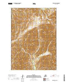
2019 Map of Sleetmute A-7 SE
USGS Topo · Published 2019About this map
Oksotalik Cr and Boss Cr define the drainage patterns of this interior region within the Bethel Census Area. The landscape is dominated by complex topographical relief, where the North American Vertical Datum of 1988 records a series of high ridges and deep valleys. Surveyed by the U.S. Geological Survey, the map provides precise elevation data for the townships of t12n r52w, t12n r51w, t11n r52w, and t11n r51w. The absence of roads or established settlements emphasizes the wilderness character of this part of Alaska during the early twenty-first century, serving as a foundational record for physical geography and hydrography in a region shaped by its watercourses.
Find a feature on this map
6 named features on this map. Tap any name to fly to it.
Don’t see what you’re looking for? This feature index may not catch every label — zoom into the map to look around manually.
Map Details
Editions of this 2019 Sleetmute A-7 SE Map
This is the sole edition of this map. No revisions or reprints were ever made.
Other maps of this area

1950 · Sleetmute
USGS Topo · 1:250,000

1950 · Taylor Mountains
USGS Topo · 1:250,000

1951 · Taylor Mountains
USGS Topo · 1:250,000

1954 · Sleetmute
USGS Topo · 1:250,000

1954 · Taylor Mountains
USGS Topo · 1:250,000

1954 · Sleetmute A-7
USGS Topo · 1:63,360

1954 · Taylor Mountains D-6
USGS Topo · 1:63,360

1954 · Sleetmute A-6
USGS Topo · 1:63,360
1954 · Taylor Mountains D-7
USGS Topo · 1:63,360
2019 · Taylor Mountains D-7 NE
USGS Topo · 1:25,000