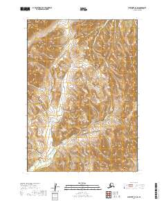
2019 Map of Sleetmute A-7 SW
USGS Topo · Published 2019About this map
The Holokuk River flows through this interior landscape of the Bethel Census Area, carving a path through the steep topographic contours of southwestern Alaska. The map illustrates a high-relief wilderness where the river is joined by significant tributaries, including the Buckstock River in the north and the winding Atsaksouluk Cr in the south. The drainage patterns of the Chikubuluk Cr further define the intricate watershed system of this remote region. While largely devoid of named settlements or man-made structures, the cartography provides a precise record of the natural terrain and water networks as they existed in the early twenty-first century, useful for understanding the hydrological and geological makeup of the Kuskokwim River basin area.
Find a feature on this map
8 named features on this map. Tap any name to fly to it.
Don’t see what you’re looking for? This feature index may not catch every label — zoom into the map to look around manually.
Map Details
Editions of this 2019 Sleetmute A-7 SW Map
This is the sole edition of this map. No revisions or reprints were ever made.
Other maps of this area

1950 · Sleetmute
USGS Topo · 1:250,000

1950 · Taylor Mountains
USGS Topo · 1:250,000

1951 · Taylor Mountains
USGS Topo · 1:250,000

1954 · Sleetmute
USGS Topo · 1:250,000

1954 · Taylor Mountains
USGS Topo · 1:250,000

1954 · Taylor Mountains D-8
USGS Topo · 1:63,360

1954 · Sleetmute A-7
USGS Topo · 1:63,360
1954 · Sleetmute A-8
USGS Topo · 1:63,360
1954 · Taylor Mountains D-7
USGS Topo · 1:63,360
2019 · Taylor Mountains D-7 NE
USGS Topo · 1:25,000