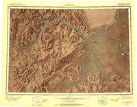
1950 Map of Sleetmute
USGS Topo · Published 1950About this map
Kuskokwim River serves as the central artery for this remote Alaskan interior, where trade and transport relied heavily on the water and a network of trading posts and riverside villages in 1950. The map records a series of commercial hubs essential to the era, including McDonalds Trading Post, Mellicks Trading Post, and Parks Trading Post. Historically significant landmarks like the Kolmakof Fort Ruins near Kolmakof Lake provide a window into earlier eras of Russian and American contact in the region.
Find a feature on this map
93 named features on this map. Tap any name to fly to it.
Don’t see what you’re looking for? This feature index may not catch every label — zoom into the map to look around manually.
Map Details
Editions of this 1950 Sleetmute Map
2 editions found
Other maps of this area

1946 · Lake Clark
USGS Topo · 1:250,000

1947 · Russian Mission
USGS Topo · 1:250,000

1949 · McGrath
USGS Topo · 1:250,000

1950 · Russian Mission
USGS Topo · 1:250,000

1950 · Sleetmute
USGS Topo · 1:250,000

1950 · McGrath
USGS Topo · 1:250,000

1950 · Bethel
USGS Topo · 1:250,000

1950 · Taylor Mountains
USGS Topo · 1:250,000

1951 · Lake Clark
USGS Topo · 1:250,000

1951 · Taylor Mountains
USGS Topo · 1:250,000