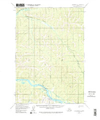
1954 Map of Sleetmute D-4
USGS Topo · Published 1975About this map
The Kuskokwim River serves as the central lifeline for this interior Alaska corridor, where the settlement of Red Devil serves as a primary hub for activity. The local economy and transport network are defined by industrial and subsistence needs, evidenced by the presence of the Barometer Mine and the Red Devil Airport. Away from the main riverbanks, the terrain is marked by a network of seasonal routes including a Tractor Trail and Jeep Trail that cut through the valleys of the South Fork George River and Fuller Creek. Small-scale seasonal or temporary sites such as Parks, Fish Camp, and scattered cabins indicate the sparse but vital human footprint in the region. The map also records the confluence of the George River and its various forks, highlighting a landscape where mobility depends heavily on both watercraft and rugged overland trails.
Find a feature on this map
21 named features on this map. Tap any name to fly to it.
Don’t see what you’re looking for? This feature index may not catch every label — zoom into the map to look around manually.
Map Details
Editions of this 1954 Sleetmute D-4 Map
3 editions found
Other maps of this area

1950 · Sleetmute
USGS Topo · 1:250,000

1951 · Iditarod
USGS Topo · 1:250,000

1954 · Sleetmute C-4
USGS Topo · 1:63,360

1954 · Sleetmute D-5
USGS Topo · 1:63,360

1954 · Sleetmute D-4
USGS Topo · 1:63,360

1954 · Sleetmute D-3
USGS Topo · 1:63,360

1954 · Sleetmute C-3
USGS Topo · 1:63,360

1954 · Iditarod A-4
USGS Topo · 1:63,360

1954 · Iditarod A-3
USGS Topo · 1:63,360

1954 · Sleetmute C-5
USGS Topo · 1:63,360