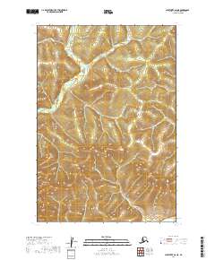
2019 Map of Sleetmute D-6 NE
USGS Topo · Published 2019About this map
The Kuskokwim River defines the southeastern corner of this Alaskan interior landscape, serving as the primary drainage and historical corridor for the surrounding highlands. This 2019 survey documents a wilderness terrain characterized by significant elevation changes, where the drainages of Bell Cr and Central Cr carve through the northern and southern reaches of the quadrangle. The lack of roads or established settlements emphasizes the remote character of the Bethel Census Area, where human presence is indicated primarily by the township and range lines of t22n r48w and t21n r47w. This map is an essential record of the contemporary Alaskan backcountry, showing the intricate natural topography and hydrologic patterns of the region's tributary systems as they flow toward the main river channel.
Find a feature on this map
7 named features on this map. Tap any name to fly to it.
Don’t see what you’re looking for? This feature index may not catch every label — zoom into the map to look around manually.
Map Details
Editions of this 2019 Sleetmute D-6 NE Map
This is the sole edition of this map. No revisions or reprints were ever made.
Other maps of this area

1950 · Sleetmute
USGS Topo · 1:250,000

1951 · Iditarod
USGS Topo · 1:250,000

1954 · Sleetmute D-5
USGS Topo · 1:63,360

1954 · Sleetmute D-6
USGS Topo · 1:63,360

1954 · Iditarod A-5
USGS Topo · 1:63,360

1954 · Iditarod A-4
USGS Topo · 1:63,360

1954 · Sleetmute
USGS Topo · 1:250,000

1956 · Iditarod
USGS Topo · 1:250,000
2019 · Sleetmute D-6 SW
USGS Topo · 1:25,000
2019 · Sleetmute D-6 NW
USGS Topo · 1:25,000