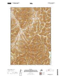
2019 Map of Sleetmute D-8 SW
USGS Topo · Published 2019About this map
Iditarod River meanders through the western portion of this Bethel Census Area landscape, showing the complex fluvial patterns typical of the Alaskan interior. This 2019 survey documents a largely undeveloped wilderness where the river systems are the primary geographical markers, flowing between the boundaries of various townships like t20n r54w and t19n r54w. In the southeastern corner, the Kolmakof River makes a brief appearance, cutting through a high-relief terrain of ridges and valleys defined by ten-foot contour intervals. The map provides a precise record of the natural topography and wetland distribution as it existed in the early 21st century, offering essential data for those studying the hydrography of the Kuskokwim River watershed.
Find a feature on this map
8 named features on this map. Tap any name to fly to it.
Don’t see what you’re looking for? This feature index may not catch every label — zoom into the map to look around manually.
Map Details
Editions of this 2019 Sleetmute D-8 SW Map
This is the sole edition of this map. No revisions or reprints were ever made.
Other maps of this area

1947 · Russian Mission
USGS Topo · 1:250,000

1950 · Russian Mission
USGS Topo · 1:250,000

1950 · Sleetmute
USGS Topo · 1:250,000

1952 · Russian Mission C-1
USGS Topo · 1:63,360

1952 · Russian Mission D-1
USGS Topo · 1:63,360
1954 · Sleetmute C-8
USGS Topo · 1:63,360
1954 · Sleetmute D-8
USGS Topo · 1:63,360

1954 · Sleetmute
USGS Topo · 1:250,000

1980 · Russian Mission
USGS Topo · 1:250,000
2019 · Sleetmute D-8 NE
USGS Topo · 1:25,000