
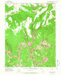
1964 Map of Slickrock Bench
USGS Topo · Published 1966About this map
Slickrock Bench and the adjacent Upper Slickrock Bench dominate this part of Kane County as they were surveyed in the early 1960s. The landscape is defined by its dramatic erosion patterns, where watercourses like Hackberry Creek have carved deep into the earth to form Hackberry Canyon. Human presence is minimal, marked primarily by a network of jeep trails and a lone Prospect near Rock Springs, suggesting a period of isolated exploration and mineral searching. Notable landmarks such as the Natural Arch and the uniquely named Rush Beds provide specific points of reference in an area otherwise characterized by sweeping plateaus and steep drops. The presence of Upper Death Valley and Death Valley Draw illustrates the harsh nature of this terrain, while Johnson Hole in the south provides a distinct topographical basin where Snake Creek originates.
Find a feature on this map
23 named features on this map. Tap any name to fly to it.
Don’t see what you’re looking for? This feature index may not catch every label — zoom into the map to look around manually.
Map Details
Editions of this 1964 Slickrock Bench Map
2 editions found
Other maps of this area

1886 · Kanab
USGS Topo · 1:250,000

1886 · Escalante
USGS Topo · 1:250,000

1953 · Cedar City
USGS Topo · 1:250,000

1955 · The Cockscob SW
USGS Topo · 1:24,000

1956 · Escalante
USGS Topo · 1:250,000

1958 · Cedar City
USGS Topo · 1:250,000

1960 · Escalante
USGS Topo · 1:250,000

1962 · Cedar City
USGS Topo · 1:250,000

1964 · Horse Flat
USGS Topo · 1:24,000

1964 · Canaan Peak
USGS Topo · 1:24,000