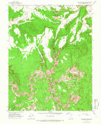
1964 Map of Slickrock Bench
USGS Topo · Published 1966About this map
Hackberry Canyon and its many winding tributaries dominate this mid-century survey of the Kane County backcountry. The landscape is defined by dramatic elevation changes between high plateaus like Slickrock Bench and deep depressions such as Johnson Hole. Evidence of human activity in this isolated terrain is sparse but specific, marked by a single Prospect and a Corral near Little Dry Valley Creek. The map documents a network of traditional routes, including the Pack Trail and several Jeep Trails, which provide the only access across the Rock Springs Bench and through the Round Valley Draw. Geological landmarks such as a Natural Arch and the expansive Rush Beds highlight the unique erosional character of the region during this era of field checking by the Geological Survey.
Find a feature on this map
25 named features on this map. Tap any name to fly to it.
Don’t see what you’re looking for? This feature index may not catch every label — zoom into the map to look around manually.
Map Details
Editions of this 1964 Slickrock Bench Map
2 editions found

Other maps of this area

1886 · Kanab
USGS Topo · 1:250,000

1886 · Escalante
USGS Topo · 1:250,000

1953 · Cedar City
USGS Topo · 1:250,000

1955 · The Cockscob SW
USGS Topo · 1:24,000

1956 · Escalante
USGS Topo · 1:250,000

1958 · Cedar City
USGS Topo · 1:250,000

1960 · Escalante
USGS Topo · 1:250,000

1962 · Cedar City
USGS Topo · 1:250,000

1964 · Horse Flat
USGS Topo · 1:24,000

1964 · Canaan Peak
USGS Topo · 1:24,000