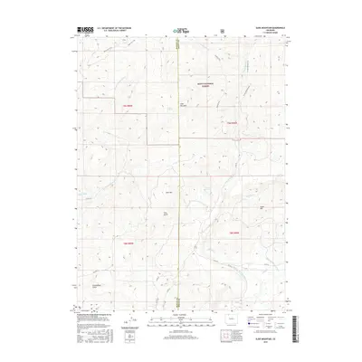
2016 Map of Slide Mountain
USGS Topo · Published 2016About this map
Routt National Forest dominates this section of the High Rockies, where the border between Moffat and Routt Counties cuts through a landscape defined by high peaks and an intricate water management system. Elevation and water rights are central to the terrain, evidenced by the presence of the Tipton Ditch and the primary flows of Elkhead Creek and Dry Fork Little Bear Creek. Prominent summits like Slide Mountain and Buck Mountain overlook a network of seasonal trails and backcountry routes, including the Bears Ears Trail and Sawmill Trail. The map documents the vital infrastructure of the Colorado high country, specifically the McKinley Ditch Number 1 and McKinley Ditch Number 2 which divert water through Long Gulch and Cottonwood Gulch. These engineering features, alongside Anderson Reservoir, illustrate the historical and ongoing importance of water distribution in this high-altitude environment.
Find a feature on this map
31 named features on this map. Tap any name to fly to it.
Don’t see what you’re looking for? This feature index may not catch every label — zoom into the map to look around manually.
Map Details
Editions of this 2016 Slide Mountain Map
This is the sole edition of this map. No revisions or reprints were ever made.
Other maps of this area

1923 · Elkhead Creek
USGS Topo · 1:62,500

1923 · Pilot Knob
USGS Topo · 1:62,500

1924 · Elkhead Creek
USGS Topo · 1:62,500

1925 · Pilot Knob
USGS Topo · 1:62,500

1954 · Craig
USGS Topo · 1:250,000

1957 · Craig
USGS Topo · 1:250,000

1958 · Craig
USGS Topo · 1:250,000

1960 · Craig
USGS Topo · 1:250,000

1962 · Craig
USGS Topo · 1:250,000
1962 · Bears Ears Peaks
USGS Topo · 1:24,000