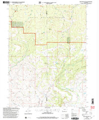
2000 Map of Slide Mountain
USGS Topo · Published 2004About this map
Routt National Forest dominates this high-country landscape at the turn of the millennium, where the boundary between Moffat and Routt counties follows the natural drainage divides. The topography is defined by prominent peaks like Slide Mountain and Buck Mountain, alongside the striking geological formation known as The Dike near Bears Ears. Water management is a visible priority in this arid environment, evidenced by the presence of Anderson Reservoir and an extensive network of irrigation infrastructure including the Tipton Ditch and Mc Kinlay Ditch. These man-made channels divert water from natural flows like Elkhead Creek and North Fork Elkhead Creek to support lower-elevation ranching and agriculture. Recreational and access routes are sparse, primarily limited to the historic Bears Ears Trail and a series of four-wheel drive roads that navigate the complex system of gulches, such as Long Gulch and Cottonwood Gulch.
Find a feature on this map
22 named features on this map. Tap any name to fly to it.
Don’t see what you’re looking for? This feature index may not catch every label — zoom into the map to look around manually.
Map Details
Editions of this 2000 Slide Mountain Map
This is the sole edition of this map. No revisions or reprints were ever made.
Other maps of this area

1923 · Elkhead Creek
USGS Topo · 1:62,500

1923 · Pilot Knob
USGS Topo · 1:62,500

1924 · Elkhead Creek
USGS Topo · 1:62,500

1925 · Pilot Knob
USGS Topo · 1:62,500

1954 · Craig
USGS Topo · 1:250,000

1957 · Craig
USGS Topo · 1:250,000

1958 · Craig
USGS Topo · 1:250,000

1960 · Craig
USGS Topo · 1:250,000

1962 · Craig
USGS Topo · 1:250,000
1962 · Bears Ears Peaks
USGS Topo · 1:24,000