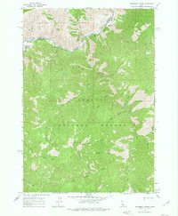
1963 Map of Sliderock Ridge
USGS Topo · Published 1975About this map
The Middle Fork Salmon River carves through the northern reaches of this Idaho wilderness, marking a significant transition between the Boise National Forest and Challis National Forest. The map documents a remote landscape defined by steep drainage systems like Little Loon Creek and Jackass Creek that feed into the river corridor. Settlement and infrastructure are sparse, limited to specialized backcountry outposts such as the Cougar Creek Ranch and the Mahoney Creek Airstrip near the riverbanks. High-elevation vantage points are noted at the Slide Rock Lookout atop Sliderock Ridge, while the Little Creek Guard Station provides a human presence in the dense timber of the southwestern quadrant. This survey reflects the mid-century wilderness management era before the formal designation of large-scale roadless areas.
Find a feature on this map
30 named features on this map. Tap any name to fly to it.
Don’t see what you’re looking for? This feature index may not catch every label — zoom into the map to look around manually.
Map Details
Editions of this 1963 Sliderock Ridge Map
3 editions found
Other maps of this area

1930 · Casto
USGS Topo · 1:125,000

1957 · Challis
USGS Topo · 1:250,000

1960 · Challis
USGS Topo · 1:250,000

1961 · Greyhound Ridge
USGS Topo · 1:62,500

1962 · Norton Ridge
USGS Topo · 1:24,000

1962 · Ramey Hill
USGS Topo · 1:24,000

1963 · Challis
USGS Topo · 1:250,000

1963 · Pinyon Peak
USGS Topo · 1:24,000

1963 · Casto
USGS Topo · 1:24,000
1963 · Sliderock Ridge
USGS Topo · 1:24,000