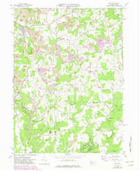
1969 Map of Sligo
USGS Topo · Published 1982About this map
Extensive industrial activity defines the terrain around Sligo and Rimersburg in this late 1960s survey. The landscape is heavily marked by numerous Strip Mines, waste piles, and a tipple, showing the scale of coal extraction in Toby and Piney townships. Transportation for this industry is provided by the Conrail line, which snakes through the valleys alongside Licking Creek.
Find a feature on this map
45 named features on this map. Tap any name to fly to it.
Don’t see what you’re looking for? This feature index may not catch every label — zoom into the map to look around manually.
Map Details
Editions of this 1969 Sligo Map
Other maps of this area

1900 · Kittanning
USGS Topo · 1:62,500

1901 · Rural Valley
USGS Topo · 1:62,500

1902 · Kittanning
USGS Topo · 1:62,500

1903 · Rural Valley
USGS Topo · 1:62,500

1906 · Clarion
USGS Topo · 1:62,500

1907 · Clarion
USGS Topo · 1:62,500

1907 · Foxburg
USGS Topo · 1:62,500

1908 · Foxburg
USGS Topo · 1:62,500

1953 · Pittsburgh
USGS Topo · 1:250,000

1954 · Pittsburgh
USGS Topo · 1:250,000