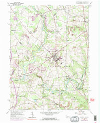
1961 Map of Slippery Rock
USGS Topo · Published 1990About this map
Slippery Rock State College serves as the focal point of this region, which was mapped at a time when the local economy transitioned between its industrial past and educational future. The landscape is defined by the winding paths of Wolf Creek and Slippery Rock Creek, along which several historic milling sites are documented, including Courtneys Mills, Currys Mills, and Christleys Mills. These small settlements, once dependent on water power, are captured alongside more modern developments like the Radio Tower and Sewage Disposal plant.
Find a feature on this map
57 named features on this map. Tap any name to fly to it.
Don’t see what you’re looking for? This feature index may not catch every label — zoom into the map to look around manually.
Map Details
Editions of this 1961 Slippery Rock Map
4 editions found
Other maps of this area

1908 · Zelienople
USGS Topo · 1:62,500

1909 · Butler
USGS Topo · 1:62,500

1910 · Zelienople
USGS Topo · 1:62,500

1910 · Hilliards
USGS Topo · 1:62,500

1911 · Butler
USGS Topo · 1:62,500

1912 · Hilliards
USGS Topo · 1:62,500

1913 · Mercer
USGS Topo · 1:62,500

1939 · Mercer
USGS Topo · 1:62,500

1943 · Mercer
USGS Topo · 1:62,500

1944 · Hilliards
USGS Topo · 1:62,500
Featured Places
- Slippery Rock, PA
- Plain Grove Township, PA
- West Liberty, PA
- North Liberty, Liberty Township
- Forestville, PA