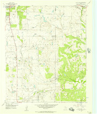
1956 Map of Sloop Creek
USGS Topo · Published 1957About this map
The Vogtsberger Oil Field dominates this mid-century landscape south of Wichita Falls, where the intersection of ranching traditions and petroleum extraction is clearly visible. The map records a transition point in North Texas land use, showing sprawling family holdings like the Rathgeber Ranch, Vogtsberger Ranch, and the McGregor Ranch (Hdqrs) interspersed with oil tanks and a Compressor Station. The drainage patterns of Sloop Creek and Lake Creek dictate the local geography, while transportation infrastructure such as the American Legion Memorial Highway and the FW & D and M K T railroads connect these rural sections to the city. Along the western edge, the presence of a Drive-in Theater and the Kickapoo Airport signal the post-war suburban expansion creeping toward the rural Wichita and Archer County line. Local education is represented by the isolated North Star Sch, serving the families of the oil fields and ranches.
Find a feature on this map
26 named features on this map. Tap any name to fly to it.
Don’t see what you’re looking for? This feature index may not catch every label — zoom into the map to look around manually.
Map Details
Editions of this 1956 Sloop Creek Map
Other maps of this area

1931 · Archer City
USGS Topo · 1:62,500

1954 · Wichita Falls
USGS Topo · 1:250,000

1956 · Sloop Creek
USGS Topo · 1:24,000

1956 · Lake Wichita
USGS Topo · 1:24,000

1957 · Wichita Falls West
USGS Topo · 1:24,000

1957 · Wichita Falls East
USGS Topo · 1:62,500

1957 · Wichita Falls East
USGS Topo · 1:24,000

1957 · Wichita Falls West
USGS Topo · 1:62,500

1958 · Wichita Falls
USGS Topo · 1:250,000

1963 · Deer Creek
USGS Topo · 1:24,000