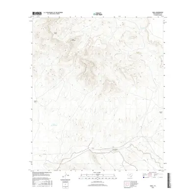
2016 Map of Small
USGS Topo · Published 2016About this map
The Finlay Mountains dominate the northern landscape of this Hudspeth County quadrangle, rising above a complex network of ephemeral drainages and desert infrastructure. The small settlement of Small sits along the southern transport corridor, where Lasca Rd parallels the modern rail line and the seasonal flow of Arroyo Balluco. This 2016 survey illustrates a high-desert environment defined by its water management, including the Finlay Mountain Tank, Telephone Tank, and Oil Well Tank. The topography is characterized by deep erosional features like Arroyo Diablo and Arroyo Macho, which cut through the arid terrain toward Gardner Draw. The presence of Lasca Branch near the southern boundary further highlights the importance of these intermittent watercourses in shaping the region's limited development and transit routes.
Find a feature on this map
11 named features on this map. Tap any name to fly to it.
Don’t see what you’re looking for? This feature index may not catch every label — zoom into the map to look around manually.
Map Details
Editions of this 2016 Small Map
This is the sole edition of this map. No revisions or reprints were ever made.
Other maps of this area

1894 · Fort Hancock
USGS Topo · 1:125,000

1895 · Sierra Blanca
USGS Topo · 1:125,000

1943 · Fort Quitman
USGS Topo · 1:62,500

1943 · Finlay Mountains
USGS Topo · 1:62,500

1948 · Triple Hill
USGS Topo · 1:62,500

1954 · Van Horn
USGS Topo · 1:250,000

1958 · Van Horn
USGS Topo · 1:250,000

1964 · Lasca
USGS Topo · 1:24,000
1972 · Silver King Canyon
USGS Topo · 1:24,000
1972 · Campo Grande Mountain
USGS Topo · 1:24,000