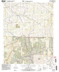
2004 Map of Smallett
USGS Topo · Published 2006About this map
Smallett and Squires anchor this portion of the Ozarks during a period of forest management and rural preservation. The landscape is defined by the Mark Twain National Forest and the Haden Bald Natural Area, which protect prominent terrain features like Haden Bald and Preston Ridge. The map reveals a deeply etched topography of hollows and ridges, including Maloney Hollow and Sugar Tree Hollow, where small settlements and homesteads once clustered near reliable water sources like South Spring Creek and Little North Fork. Genealogists will find a high density of small family and community burial grounds, such as Krider Cem, Holt Cem, and the Norris-Piland Cem. This documentation by the Forest Service captures the rural infrastructure along the Gladetop Trail, maintaining a record of country churches like Walnut Grove Ch and New Harmony Ch that served these isolated Missouri communities.
Find a feature on this map
50 named features on this map. Tap any name to fly to it.
Don’t see what you’re looking for? This feature index may not catch every label — zoom into the map to look around manually.
Map Details
Editions of this 2004 Smallett Map
This is the sole edition of this map. No revisions or reprints were ever made.
Other maps of this area

1936 · Thornfield
USGS Topo · 1:48,000

1936 · Ava
USGS Topo · 1:48,000

1937 · Bradleyville
USGS Topo · 1:48,000

1942 · Ava
USGS Topo · 1:62,500

1943 · Protem
USGS Topo · 1:62,500

1943 · Thornfield
USGS Topo · 1:62,500

1943 · Bradleyville
USGS Topo · 1:62,500

1945 · Ava
USGS Topo · 1:62,500

1945 · Harrison
USGS Topo · 1:250,000

1945 · Thornfield
USGS Topo · 1:62,500