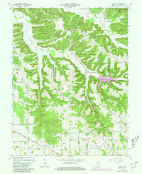
1966 Map of Smedley
USGS Topo · Published 1981About this map
Smedley and its predecessor, Old Smedley, anchor this portion of Washington County, illustrating the shifting centers of local life. The map reveals a landscape defined by sharp elevation changes, where the Jackson-Washington State Forest covers the northeastern heights and several ridgelines, such as Fleener Ridge and Mount Carmel Ridge, dictate the placement of early roads and homesteads. Settlement patterns follow the valley floors and narrow hollows, particularly along Rush Creek and the North Fork Lost River. Local infrastructure is marked by several small rural hubs like Haleysburg, which supported its own Haleyburg Sch, and Hitchcock along the rail line. The concentration of religious and educational landmarks, including Oak Grove Ch, Enon Ch, and the Walnut Grove Sch, provides researchers with a detailed view of the community's social footprint during the mid-20th century before significant modern development.
Find a feature on this map
49 named features on this map. Tap any name to fly to it.
Don’t see what you’re looking for? This feature index may not catch every label — zoom into the map to look around manually.
Map Details
Editions of this 1966 Smedley Map
3 editions found
Other maps of this area

1934 · Bedford
USGS Topo · 1:48,000

1937 · Bedford
USGS Topo · 1:62,500

1950 · Salem
USGS Topo · 1:24,000

1950 · Becks Mill
USGS Topo · 1:24,000

1951 · Smedley
USGS Topo · 1:24,000

1953 · Kossuth
USGS Topo · 1:24,000

1956 · Vincennes
USGS Topo · 1:250,000

1957 · Vincennes
USGS Topo · 1:250,000

1957 · Campbellsburg
USGS Topo · 1:24,000

1957 · Livonia
USGS Topo · 1:24,000