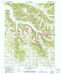
1966 Map of Smedley
USGS Topo · Published 1994About this map
The Lost River winds through the southern landscape of this mid-1960s survey, marking a region defined by its complex drainage systems and small rural settlements. Small communities like Smedley and Prowsville anchor the agricultural and timbered lands of Washington County, while the northern reaches transition into the protected acreage of the Jackson-Washington State Forest. The map documents a dense network of local landmarks, including many churches such as New Zion Ch and the Highland Friends Ch, alongside educational relics like the Walnut Grove Sch. This period shows the transition from earlier pioneer tracks to more established county roads such as Cox Ferry Road and Wheeler Hollow Rd. For genealogists, the inclusion of several burying grounds, notably the Old Smedley Cem and Covenanter Cem, provides vital coordinates for family history research in this corner of Indiana.
Find a feature on this map
49 named features on this map. Tap any name to fly to it.
Don’t see what you’re looking for? This feature index may not catch every label — zoom into the map to look around manually.
Map Details
Editions of this 1966 Smedley Map
3 editions found
Other maps of this area

1934 · Bedford
USGS Topo · 1:48,000

1937 · Bedford
USGS Topo · 1:62,500

1950 · Salem
USGS Topo · 1:24,000

1950 · Becks Mill
USGS Topo · 1:24,000

1951 · Smedley
USGS Topo · 1:24,000

1953 · Kossuth
USGS Topo · 1:24,000

1956 · Vincennes
USGS Topo · 1:250,000

1957 · Vincennes
USGS Topo · 1:250,000

1957 · Campbellsburg
USGS Topo · 1:24,000

1957 · Livonia
USGS Topo · 1:24,000