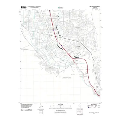
2010 Map of Smeltertown
USGS Topo · Published 2010About this map
The Rio Grande serves as a natural and political boundary in this borderlands survey, defining the western edge of El Paso and the Mesilla Valley. To the south, the international border between the United States of America and Estados Unidos Mexicanos is marked by the International Dam and the American Diversion Dam. The industrial and academic history of the region is evident near the river's bend, where the University of Texas El Paso and Old Fort Bliss sit just north of the namesake Smeltertown. Residential expansion is visible in the suburban layouts of Coronado Hills and Montoya, while the northern reaches of the quadrangle feature water management infrastructure like Thorn Reservoir and Mulberry Reservoir tucked near the base of the Franklin Mountains. Further west, the map details the Sunland Park Racetrack and the Green Acres Colonia, illustrating the varied land use between El Paso's urban core and the New Mexico state line.
Find a feature on this map
54 named features on this map. Tap any name to fly to it.
Don’t see what you’re looking for? This feature index may not catch every label — zoom into the map to look around manually.
Map Details
Editions of this 2010 Smeltertown Map
This is the sole edition of this map. No revisions or reprints were ever made.
Other maps of this area

1896 · El Paso
USGS Topo · 1:125,000

1908 · El Paso
USGS Topo · 1:125,000

1917 · Canutillo
USGS Topo · 1:62,500

1919 · Canutillo
USGS Topo · 1:62,500

1939 · Ysleta
USGS Topo · 1:62,500

1941 · El Paso
USGS Topo · 1:31,680

1941 · Ysleta
USGS Topo · 1:62,500

1942 · Fort Bliss
USGS Topo · 1:62,500

1943 · El Paso
USGS Topo · 1:31,680

1945 · Ysleta
USGS Topo · 1:62,500