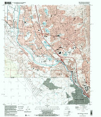
1996 Map of Smeltertown
USGS Topo · Published 2002About this map
Smeltertown and the borderlands of the Rio Grande define this international landscape where El Paso, Texas, meets Sunland Park, New Mexico, and Ciudad Juarez, Mexico. The 1990s environment is a complex intersection of infrastructure and industry, marked by the American Canal, extensive rail networks including the Southern Pacific Railroad, and the prominent Sunland Park Racetrack.
Find a feature on this map
79 named features on this map. Tap any name to fly to it.
Don’t see what you’re looking for? This feature index may not catch every label — zoom into the map to look around manually.
Map Details
Editions of this 1996 Smeltertown Map
This is the sole edition of this map. No revisions or reprints were ever made.
Other maps of this area

1896 · El Paso
USGS Topo · 1:125,000

1908 · El Paso
USGS Topo · 1:125,000

1917 · Canutillo
USGS Topo · 1:62,500

1919 · Canutillo
USGS Topo · 1:62,500

1939 · Ysleta
USGS Topo · 1:62,500

1941 · El Paso
USGS Topo · 1:31,680

1941 · Ysleta
USGS Topo · 1:62,500

1942 · Fort Bliss
USGS Topo · 1:62,500

1943 · El Paso
USGS Topo · 1:31,680

1945 · Ysleta
USGS Topo · 1:62,500