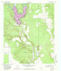
1962 Map of Smith Tank
USGS Topo · Published 1982About this map
The White River Reservoir dominates this West Texas landscape, representing a significant post-war water management project in the Caprock canyons. Established at the confluence of several drainages, the reservoir is fed by Duck Creek, Sand Creek, and the White River, with the White River Dam and a nearby Pumping Station facilitating water distribution. This 1962 survey, updated with 1981 photorevisions, shows the infrastructure required to manage these semi-arid plains, including a Substation and various Quarries that point to local extraction and maintenance. The map also delineates the convergence of four counties—Crosby, Dickens, Garza, and Kent—where the terrain transitions through several creek systems like Home Creek. Landowners and local historians can trace fence lines and find family landmarks like Smith Tank, providing a clear record of the area's rural development and agricultural boundaries during the mid-to-late 20th century.
Find a feature on this map
13 named features on this map. Tap any name to fly to it.
Don’t see what you’re looking for? This feature index may not catch every label — zoom into the map to look around manually.
Map Details
Editions of this 1962 Smith Tank Map
2 editions found
Other maps of this area

1954 · Lubbock
USGS Topo · 1:250,000

1961 · Bunker Hill
USGS Topo · 1:24,000

1962 · Twomile Creek
USGS Topo · 1:24,000

1962 · Smith Tank
USGS Topo · 1:24,000

1966 · Kalgary
USGS Topo · 1:24,000

1966 · Collett Springs
USGS Topo · 1:24,000

1967 · Spur NW
USGS Topo · 1:24,000

1968 · Foreman Chapel
USGS Topo · 1:24,000

1968 · Spur SW
USGS Topo · 1:24,000

1969 · Verbena
USGS Topo · 1:24,000