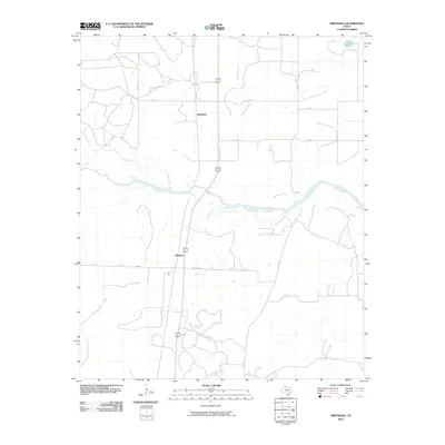
2010 Map of Smithdale
USGS Topo · Published 2010About this map
Smithdale and the small settlement of Abington anchor this northern Texas landscape, situated within a network of drainage systems and rural transit routes. The geography is defined by the significant path of the Prairie Dog Town Fork Red River, which bisects the quadrangle from west to east. Tributaries such as Gypsum Creek and Salt Creek feed into this major river fork, reflecting the hydrologic character of the region. The transport network is a mix of local farm-to-market and ranch roads, including Fm 2485 and Ranch Rd 2465, which provide access between the scattered homesteads and larger regional corridors. The map reveals a highly structured grid of county roads, such as Co RD 11 and Co RD K, illustrating the organized land division typical of this agrarian and ranching territory.
Find a feature on this map
17 named features on this map. Tap any name to fly to it.
Don’t see what you’re looking for? This feature index may not catch every label — zoom into the map to look around manually.
Map Details
Editions of this 2010 Smithdale Map
This is the sole edition of this map. No revisions or reprints were ever made.
Other maps of this area

1954 · Plainview
USGS Topo · 1:250,000

1958 · Plainview
USGS Topo · 1:250,000

1960 · Loco
USGS Topo · 1:62,500

1961 · Estelline
USGS Topo · 1:62,500

1967 · Kirkland North
USGS Topo · 1:24,000

1967 · Childress
USGS Topo · 1:24,000

1967 · Carey
USGS Topo · 1:24,000
1984 · Arlie
USGS Topo · 1:24,000

1984 · Estelline NE
USGS Topo · 1:24,000
1984 · Loco
USGS Topo · 1:24,000