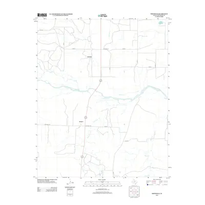
2012 Map of Smithdale
USGS Topo · Published 2012About this map
Smithdale and Abington anchor this section of Childress County, illustrating a landscape defined by ranching and the intricate drainage systems of the eastern Texas Panhandle. The most prominent geographic feature is the Prairie Dog Town Fork Red River, which cuts across the central portion of the map, fed by several significant seasonal watercourses including Salt Cr and Gypsum Cr. The road network is primarily composed of county roads and ranch access routes, such as Vest Ranch Rd and Ranch Road 2465, which navigate the terrain around Conkline Cr and Whites Cr. This 2012 survey provides a clear view of the sparse rural settlement patterns typical of the region, where wide-open spaces are segmented by a grid of local routes supporting the local agricultural and ranching economy.
Find a feature on this map
17 named features on this map. Tap any name to fly to it.
Don’t see what you’re looking for? This feature index may not catch every label — zoom into the map to look around manually.
Map Details
Editions of this 2012 Smithdale Map
This is the sole edition of this map. No revisions or reprints were ever made.
Other maps of this area

1954 · Plainview
USGS Topo · 1:250,000

1958 · Plainview
USGS Topo · 1:250,000

1960 · Loco
USGS Topo · 1:62,500

1961 · Estelline
USGS Topo · 1:62,500

1967 · Kirkland North
USGS Topo · 1:24,000

1967 · Childress
USGS Topo · 1:24,000

1967 · Carey
USGS Topo · 1:24,000
1984 · Arlie
USGS Topo · 1:24,000

1984 · Estelline NE
USGS Topo · 1:24,000
1984 · Loco
USGS Topo · 1:24,000