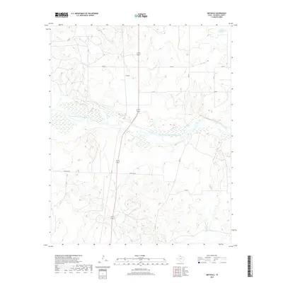
2019 Map of Smithdale
USGS Topo · Published 2019About this map
Prairie Dog Town Fork Red River dominates the central landscape of this Childress County region, creating a wide, braided basin where Gypsum Cr and Salt Cr join the main flow. The settlement of Smithdale sits just north of this drainage divide, situated along the primary north-south corridor that bisects the ranching and agricultural lands. The terrain is marked by a complex network of draws and intermittent streams, including Conkline Cr and Whites Cr, which define the local topography. This survey captures the rural infrastructure of the late 2010s, where traditional county roads like Co RD K and Co RD 17 intersect with Ranch Rd 2465, illustrating the persistent grid of West Texas land management and its relationship to the natural watercourses.
Find a feature on this map
15 named features on this map. Tap any name to fly to it.
Don’t see what you’re looking for? This feature index may not catch every label — zoom into the map to look around manually.
Map Details
Editions of this 2019 Smithdale Map
This is the sole edition of this map. No revisions or reprints were ever made.
Other maps of this area

1954 · Plainview
USGS Topo · 1:250,000

1958 · Plainview
USGS Topo · 1:250,000

1960 · Loco
USGS Topo · 1:62,500

1961 · Estelline
USGS Topo · 1:62,500

1967 · Kirkland North
USGS Topo · 1:24,000

1967 · Childress
USGS Topo · 1:24,000

1967 · Carey
USGS Topo · 1:24,000
1984 · Arlie
USGS Topo · 1:24,000

1984 · Estelline NE
USGS Topo · 1:24,000
1984 · Loco
USGS Topo · 1:24,000