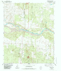
1985 Map of Smithdale
USGS Topo · Published 1985About this map
The Prairie Dog Town Fork Red River carves a wide, braided path through this portion of Childress Co., shaping a landscape defined by erosion and seasonal water flow. In the mid-1980s, the small settlement of Smithdale sat north of the river, positioned near the confluence of Cottonwood Creek and Gypsum Creek. This area illustrates the logistical importance of the Panhandle's drainage systems and the infrastructure required to manage them, evidenced by a Gaging Sta along the riverbanks.
Find a feature on this map
13 named features on this map. Tap any name to fly to it.
Don’t see what you’re looking for? This feature index may not catch every label — zoom into the map to look around manually.
Map Details
Editions of this 1985 Smithdale Map
This is the sole edition of this map. No revisions or reprints were ever made.
Other maps of this area

1954 · Plainview
USGS Topo · 1:250,000

1958 · Plainview
USGS Topo · 1:250,000

1960 · Loco
USGS Topo · 1:62,500

1961 · Estelline
USGS Topo · 1:62,500

1967 · Kirkland North
USGS Topo · 1:24,000

1967 · Childress
USGS Topo · 1:24,000

1967 · Carey
USGS Topo · 1:24,000
1984 · Arlie
USGS Topo · 1:24,000

1984 · Estelline NE
USGS Topo · 1:24,000
1984 · Loco
USGS Topo · 1:24,000