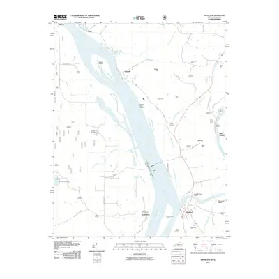
2011 Map of Smithland
USGS Topo · Published 2011About this map
Smithland sits at the significant confluence where the Cumberland River meets the Ohio River, a junction long defined by river navigation and commerce. This early 21st-century landscape highlights the persistent connection between the waterway and industrial extraction, evidenced by the Three Rivers Quarry and Dyer Hill Mine. Across the water, Hamletsburg and Bay City anchor the Illinois shoreline, while the interior of the quadrangle is marked by numerous family and community burial grounds, such as Kickasola Cemetery and Sloan Cemetery. The Lucy Jefferson Lewis Memorial Bridge provides a vital link over the Cumberland, connecting the riverfront settlement of Smithland to the rising terrain of Cemetery Hill and Japanese Hill. The river itself is dominated by large features like Stewart Island and Dog Island, which shape the channels used by modern river traffic and historical landings like Morrison Landing.
Find a feature on this map
72 named features on this map. Tap any name to fly to it.
Don’t see what you’re looking for? This feature index may not catch every label — zoom into the map to look around manually.
Map Details
Editions of this 2011 Smithland Map
This is the sole edition of this map. No revisions or reprints were ever made.
Other maps of this area

1916 · Golconda
USGS Topo · 1:62,500

1917 · Brownfield
USGS Topo · 1:62,500

1920 · Goloonda
USGS Topo · 1:48,000

1921 · Golconda
USGS Topo · 1:62,500

1926 · Paducah
USGS Topo · 1:62,500

1929 · Smithland
USGS Topo · 1:62,500

1929 · Paducah
USGS Topo · 1:62,500

1936 · Paducah
USGS Topo · 1:24,000

1936 · Smithland
USGS Topo · 1:48,000
1936 · Calvert City
USGS Topo · 1:24,000