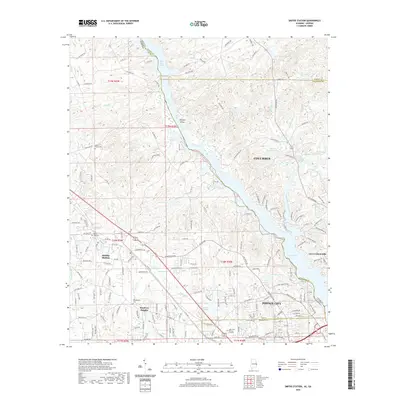
2020 Map of Smiths Station
USGS Topo · Published 2020About this map
Goat Rock Lake and Lake Oliver dominate the eastern border of this 2020 survey, marking the aquatic boundary between Alabama and Georgia. The landscape is characterized by a mix of residential expansion and preserved water bodies, with Smiths Station serving as a primary settlement hub. Along the southern reaches, the growing outskirts of Phenix City and Columbus begin to interface with the more rural reaches of Lee and Muscogee Counties. Genealogists and local historians will find several established burial grounds documented, including Philadelphia Cem and Mount Zion Cem, which sit alongside family-named landmarks and smaller reservoirs like Lake Clarmar and Webbs Pond. The terrain is intricately carved by creek systems such as Soap Cr and Holland Cr, illustrating the hydrological network that feeds the larger Chattahoochee River reservoirs.
Find a feature on this map
189 named features on this map. Tap any name to fly to it.
Don’t see what you’re looking for? This feature index may not catch every label — zoom into the map to look around manually.
Map Details
Editions of this 2020 Smiths Station Map
This is the sole edition of this map. No revisions or reprints were ever made.
Other maps of this area

1907 · Talbotton
USGS Topo · 1:125,000

1907 · Opelika
USGS Topo · 1:125,000

1908 · Columbus
USGS Topo · 1:62,500

1909 · Opelika
USGS Topo · 1:125,000

1914 · Seale
USGS Topo · 1:62,500

1929 · Columbus
USGS Topo · 1:48,000

1947 · Columbus
USGS Topo · 1:62,500

1949 · Columbus
USGS Topo · 1:24,000

1950 · Fortson
USGS Topo · 1:24,000

1950 · Mulberry Grove
USGS Topo · 1:24,000
Featured Places
- Columbus, GA
- Phenix City, AL
- Smiths Station, AL
- Monterey Heights, Smiths Station
- Carriage Hill, Phenix City