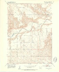
1951 Map of Smithwick NW
USGS Topo · Published 1953About this map
The Cheyenne River winds through the heart of this landscape along the border of Custer and Fall River counties, creating a complex network of seasonal drainages and elevated plateaus. On the southern banks, the expansive W G Flat dominates the topography, serving as the site for the rural W G Flat Sch. This 1951 field-checked survey highlights the significance of water management and land use in the Missouri River Basin development program, with detailed mapping of numerous draws and intermittent streams including Iron Draw, W G Draw, and Plumb Creek. To the north, the terrain transitions into the high ground of Harrison Flat and the depressions of Johnny Creek. This map preserves the mid-century layout of these remote cattle-ranching and dryland farming areas before significant modern alterations.
Find a feature on this map
12 named features on this map. Tap any name to fly to it.
Don’t see what you’re looking for? This feature index may not catch every label — zoom into the map to look around manually.
Map Details
Editions of this 1951 Smithwick NW Map
3 editions found
Other maps of this area

1894 · Hermosa
USGS Topo · 1:125,000

1896 · Oelrichs
USGS Topo · 1:125,000

1900 · Oelrichs
USGS Topo · 1:125,000

1901 · Hermosa
USGS Topo · 1:125,000

1950 · Buffalo Gap
USGS Topo · 1:24,000

1950 · Hot Springs SE
USGS Topo · 1:24,000

1951 · Fairburn SE
USGS Topo · 1:24,000

1951 · Smithwick NE
USGS Topo · 1:24,000

1951 · Smithwick NW
USGS Topo · 1:24,000

1955 · Hot Springs
USGS Topo · 1:250,000