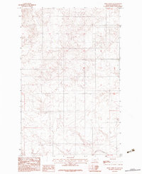
1983 Map of Smoke Creek SW
USGS Topo · Published 1983About this map
Fort Peck Indian Reservation land characterizes this section of Roosevelt County, where the topography transitions through subtle elevation changes across the Montana plains. The landscape is defined by the drainage patterns of Lake Creek, which winds through the southern portion of the quadrangle. As a provisional document produced by the U.S. Geological Survey in the early 1980s, the map focuses on the complex network of section lines and township boundaries, including the transition between T30N and T29N. This survey provides a technical view of a sparsely populated area, emphasizing the natural coulees and watercourses rather than established settlements, reflecting the open character of the northeastern Montana prairie during this era.
Find a feature on this map
4 named features on this map. Tap any name to fly to it.
Don’t see what you’re looking for? This feature index may not catch every label — zoom into the map to look around manually.
Map Details
Editions of this 1983 Smoke Creek SW Map
This is the sole edition of this map. No revisions or reprints were ever made.
Other maps of this area

1909 · Smoke Creek
USGS Topo · 1:62,500

1912 · Hay Creek
USGS Topo · 1:62,500

1912 · Poplar
USGS Topo · 1:62,500

1912 · Smoke Creek
USGS Topo · 1:62,500

1914 · Brockton
USGS Topo · 1:62,500

1950 · Coyote Coulee
USGS Topo · 1:24,000

1950 · Calais
USGS Topo · 1:24,000

1954 · Wolf Point
USGS Topo · 1:250,000

1958 · Wolf Point
USGS Topo · 1:250,000

1972 · Poplar NE
USGS Topo · 1:24,000