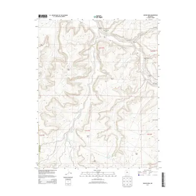
2013 Map of Smouse Mesa
USGS Topo · Published 2013About this map
San Juan Basin Gas Field infrastructure defines the southern reaches of this high-desert landscape on the border of San Juan and Rio Arriba Counties. The terrain is characterized by a series of prominent plateaus, including Smouse Mesa, Superior Mesa, and Cibolo Mesa, which are dissected by deep drainage systems like Cañon Largo and Palluche Canyon. Evidence of land use and seasonal activity appears at Largo Camp and Truby Ranch, while vital water sources are scattered throughout the draws, such as Hooch Spring and Doe Spring. The map documents a rugged interior network of routes, including Co Road 367 and Co Road 523, which provide access to these remote mesas and the natural gas developments that have shaped the regional economy in the early 21st century.
Find a feature on this map
30 named features on this map. Tap any name to fly to it.
Don’t see what you’re looking for? This feature index may not catch every label — zoom into the map to look around manually.
Map Details
Editions of this 2013 Smouse Mesa Map
This is the sole edition of this map. No revisions or reprints were ever made.
Other maps of this area

1889 · Largo
USGS Topo · 1:250,000

1895 · Largo
USGS Topo · 1:250,000

1954 · Aztec
USGS Topo · 1:250,000

1958 · Aztec
USGS Topo · 1:250,000

1959 · Gould Pass
USGS Topo · 1:62,500

1959 · Nageezi
USGS Topo · 1:62,500

1962 · Aztec
USGS Topo · 1:250,000

1963 · Tayfoya Canyon
USGS Topo · 1:24,000

1963 · Gonzales Mesa
USGS Topo · 1:24,000
1963 · Santos Peak
USGS Topo · 1:24,000