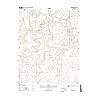
2017 Map of Smouse Mesa
USGS Topo · Published 2017About this map
Smouse Mesa and Cibolo Mesa dominate this high-desert landscape in the San Juan Basin, where the drainages of Palluche Wash and Canon Largo have carved deep networks of canyons. The map documents a sparsely populated region defined by its reliance on isolated water sources such as Hooch Spring, Romero Spring, and Doe Spring. These natural features, along with Wild Horse Lake, provided critical anchors for ranching and travel in a territory where roads like Largo Canyon Rd follow the natural contours of the floor. The boundary between San Juan and Rio Arriba counties cuts through the southwestern corner, marking a transition between these two prominent New Mexico administrative districts. Landforms like Superior Mesa and Black Ridge provide clear landmarks for navigating the complex topography of Palluche Canyon and Dogie Canyon.
Find a feature on this map
26 named features on this map. Tap any name to fly to it.
Don’t see what you’re looking for? This feature index may not catch every label — zoom into the map to look around manually.
Map Details
Editions of this 2017 Smouse Mesa Map
This is the sole edition of this map. No revisions or reprints were ever made.
Other maps of this area

1889 · Largo
USGS Topo · 1:250,000

1895 · Largo
USGS Topo · 1:250,000

1954 · Aztec
USGS Topo · 1:250,000

1958 · Aztec
USGS Topo · 1:250,000

1959 · Gould Pass
USGS Topo · 1:62,500

1959 · Nageezi
USGS Topo · 1:62,500

1962 · Aztec
USGS Topo · 1:250,000

1963 · Tayfoya Canyon
USGS Topo · 1:24,000

1963 · Gonzales Mesa
USGS Topo · 1:24,000
1963 · Santos Peak
USGS Topo · 1:24,000