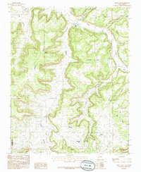
1985 Map of Smouse Mesa
USGS Topo · Published 1985About this map
Largo Canyon and its many offshoots carve through the high plateaus of northern New Mexico in this mid-1980s provisional study. The landscape is defined by massive tablelands like Smouse Mesa, Superior Mesa, and Cibolo Mesa, which are separated by a complex network of drainages including Little Palluche Canyon and Encinada Canyon. The presence of the San Juan Co Rio Arriba Co boundary line underscores the area's geography as a transition between administrative districts.
Find a feature on this map
26 named features on this map. Tap any name to fly to it.
Don’t see what you’re looking for? This feature index may not catch every label — zoom into the map to look around manually.
Map Details
Editions of this 1985 Smouse Mesa Map
This is the sole edition of this map. No revisions or reprints were ever made.
Other maps of this area

1889 · Largo
USGS Topo · 1:250,000

1895 · Largo
USGS Topo · 1:250,000

1954 · Aztec
USGS Topo · 1:250,000

1958 · Aztec
USGS Topo · 1:250,000

1959 · Gould Pass
USGS Topo · 1:62,500

1959 · Nageezi
USGS Topo · 1:62,500

1962 · Aztec
USGS Topo · 1:250,000

1963 · Tayfoya Canyon
USGS Topo · 1:24,000

1963 · Gonzales Mesa
USGS Topo · 1:24,000
1963 · Santos Peak
USGS Topo · 1:24,000