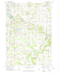
1972 Map of Smyrna
USGS Topo · Published 1974About this map
The Flat River winds through the borderlands of Ionia, Kent, and Montcalm counties, anchoring a landscape where agricultural history and waterway recreation meet. In the early 1970s, this area retained its rural character, notably preserved at Whites Bridge (Covered) and the sprawling Flat River State Game Area. The settlement of Smyrna sits at a junction of regional roads near the river, while the Chesapeake and Ohio railroad corridor tracks across the southern townships, passing the small clusters of Moseley and Alton.
Find a feature on this map
61 named features on this map. Tap any name to fly to it.
Don’t see what you’re looking for? This feature index may not catch every label — zoom into the map to look around manually.
Map Details
Editions of this 1972 Smyrna Map
This is the sole edition of this map. No revisions or reprints were ever made.
Other maps of this area

1916 · Ionia
USGS Topo · 1:62,500

1918 · Ionia
USGS Topo · 1:62,500

1918 · Lowell
USGS Topo · 1:62,500

1943 · Ionia
USGS Topo · 1:62,500

1943 · Lowell
USGS Topo · 1:62,500

1954 · Midland
USGS Topo · 1:250,000

1958 · Midland
USGS Topo · 1:250,000

1958 · Grand Rapids
USGS Topo · 1:250,000

1959 · Midland
USGS Topo · 1:250,000

1961 · Grand Rapids
USGS Topo · 1:250,000