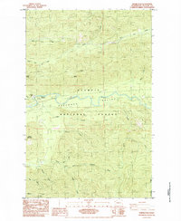
1984 Map of Snider Peak
USGS Topo · Published 1984About this map
Olympic National Forest land dominates this 1984 survey, defined by the heavy timber and high ridges of the Pacific Northwest. The Soleduck River Valley serves as the primary corridor for movement, where the Soleduck River winds through a landscape marked by the Old Railroad Grade, a relic of the era's industrial logging infrastructure. Public land management is centered at the Snider FS Station and the nearby Klahowya Campground, while a network of peaks like Snider Peak and Bigler Mountain rise above the drainage systems of the North Fork Calawah River and Bear Creek. Researchers will find evidence of local resource extraction in the various Gravel Pit locations, supporting the road network that connects several mile markers and creek crossings across the mountainous Clallam County interior.
Find a feature on this map
30 named features on this map. Tap any name to fly to it.
Don’t see what you’re looking for? This feature index may not catch every label — zoom into the map to look around manually.
Map Details
Editions of this 1984 Snider Peak Map
This is the sole edition of this map. No revisions or reprints were ever made.
Other maps of this area

1918 · Lake Crescent
USGS Topo · 1:62,500

1922 · Pysht
USGS Topo · 1:62,500

1922 · Lake Crescent
USGS Topo · 1:62,500

1939 · Mount Tom
USGS Topo · 1:62,500

1942 · Pysht
USGS Topo · 1:62,500

1943 · Spruce Mountain
USGS Topo · 1:62,500

1943 · Copalis Beach
USGS Topo · 1:250,000

1950 · Mount Muller
USGS Topo · 1:24,000

1950 · Twin Rivers
USGS Topo · 1:24,000

1950 · Slide Peak
USGS Topo · 1:24,000