
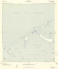
1943 Map of Snipe Keys
USGS Topo · Published 1943About this map
Snipe Keys and the surrounding labyrinth of Precinct 8 are revealed in this 1943 survey, which was originally compiled from air photographs by the U. S. Coast and Geodetic Survey for military use. The map documents a complex seascape of mangrove islands and tidal channels, including Barracuda Key Channel and Mud Key Channel, which served as vital navigational arteries through the shallow basins.
Find a feature on this map
42 named features on this map. Tap any name to fly to it.
Don’t see what you’re looking for? This feature index may not catch every label — zoom into the map to look around manually.
Map Details
Editions of this 1943 Snipe Keys Map
2 editions found
Other maps of this area

1921 · Sugar Loaf Key
USGS Topo · 1:62,500

1921 · Key West
USGS Topo · 1:62,500

1943 · Bay Keys
USGS Topo · 1:24,000

1943 · Saddlebunch Keys
USGS Topo · 1:24,000

1943 · Boca Chica
USGS Topo · 1:24,000

1943 · Key West
USGS Topo · 1:24,000

1943 · Sugarloaf Key
USGS Topo · 1:24,000

1962 · Key West
USGS Topo · 1:24,000

1968 · Saddlebunch Keys
USGS Topo · 1:24,000

1971 · Key West
USGS Topo · 1:24,000