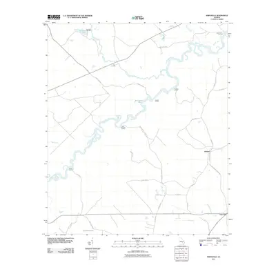
2011 Map of Snipesville
USGS Topo · Published 2011About this map
The Ocmulgee River meanders through the heart of this Jeff Davis County landscape, defining the character of the terrain with its intricate bends and associated backwaters like Montgomery Lake. This survey captures the rural layout of the region, anchored by the settlement of Snipesville in the southeast and Kirkland to its north. The river's importance to local travel and commerce is evidenced by numerous named points of access, including Burket Ferry Landing, Haddocks Landing, and Rocky Hammock Landing.
Find a feature on this map
36 named features on this map. Tap any name to fly to it.
Don’t see what you’re looking for? This feature index may not catch every label — zoom into the map to look around manually.
Map Details
Editions of this 2011 Snipesville Map
This is the sole edition of this map. No revisions or reprints were ever made.
Other maps of this area

1953 · Waycross
USGS Topo · 1:250,000

1958 · Waycross
USGS Topo · 1:250,000

1971 · Roper
USGS Topo · 1:24,000

1971 · Jacksonville NE
USGS Topo · 1:24,000

1971 · Snipesville
USGS Topo · 1:24,000

1971 · Broxton NE
USGS Topo · 1:24,000

1971 · Denton
USGS Topo · 1:24,000
1971 · Lumber City
USGS Topo · 1:24,000

1972 · Broxton North
USGS Topo · 1:24,000

1972 · Jacksonville
USGS Topo · 1:24,000