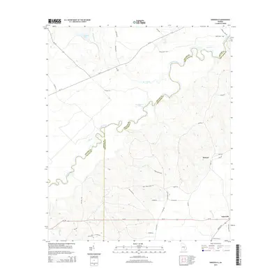
2014 Map of Snipesville
USGS Topo · Published 2014About this map
The Ocmulgee River meanders across this landscape, defining the winding political boundaries of Telfair and Jeff Davis counties. The terrain is a network of waterways and swampy lowland features including Montgomery Lake, Varnadoe Lake, and Horse Creek. Toward the southeast, the settlement of Snipesville sits at the junction of Ga-107 and Broxton Hwy, while the community of Kirkland is tucked further north among a grid of timber and family roads. Genealogists and local researchers can identify significant burial sites such as Saint Andrews Cem and Hall Cem. The presence of labels like Dodge Boon Lndg and Bunketts Ferry Rd suggests a history of river-dependent transit and river crossings that once linked these rural Georgia communities across the Ocmulgee's shifting banks.
Find a feature on this map
44 named features on this map. Tap any name to fly to it.
Don’t see what you’re looking for? This feature index may not catch every label — zoom into the map to look around manually.
Map Details
Editions of this 2014 Snipesville Map
This is the sole edition of this map. No revisions or reprints were ever made.
Other maps of this area

1953 · Waycross
USGS Topo · 1:250,000

1958 · Waycross
USGS Topo · 1:250,000

1971 · Roper
USGS Topo · 1:24,000

1971 · Jacksonville NE
USGS Topo · 1:24,000

1971 · Snipesville
USGS Topo · 1:24,000

1971 · Broxton NE
USGS Topo · 1:24,000

1971 · Denton
USGS Topo · 1:24,000
1971 · Lumber City
USGS Topo · 1:24,000

1972 · Broxton North
USGS Topo · 1:24,000

1972 · Jacksonville
USGS Topo · 1:24,000